Saturday, May 20, 2023

Bugs and Birds

Bugs and Birds

Wednesday May 17 and Thursday May 18, 2023


It was long 360 mile drive up from Coral Pink Sand Dunes to our next destination, Antelope Island, north west of Salt Lake City. The traffic was quite heavy for the last 60 miles and we were tired by the time we reached the State Park entrance. I didn’t see the notice that said “No-see-ums have hatched - no refunds due to bugs - head nets available for purchase” … but Gloria saw it.


Antelope Island is about 12 miles long and two miles wide, and is situated in the south east corner of the Great Salt Lake. The land was farmed / ranched from the early 1800s until 1981 when it became a State Park. Historically cattle and sheep were raised on the island, but more recently it is home to a large herd of bison, perhaps 500 or so in total. In the past, access was by boat, or in times of drought, by walking across a sand bar, but now there is a man-made causeway with a tarmac road. It’s quite a mountainous island and, as crazy as it sounds, it reminded me of some parts of the west coast of Scotland, with hills dropping down to white sand beaches, the sea and more mountains in the distance.


As we drove over the causeway we stopped to look at the birds, which seemed to be present in vast numbers. We were excited to see California and Franklins gulls, as well as black bellied plover and several avocets. We also couldn’t help noticing the clouds of insects that rose up like smoke from the grasses and shrubs by the side of the road. (If you think I am exaggerating see the photos below!). As we approached the campground our concerns changed from whether there would be any shade to if we could stand camping amongst the insects. In a moment of profound common sense we decided to sit at the picnic table for a few minutes before putting up the tent. We had on our bug nets (purchased prior to our Alaska trip last year), but nonetheless it took us about two minutes to realize that we couldn’t stay there. It was a beautiful site, overlooking the Great Salt Lake, but the bugs were unbelievable. The “midge flies”, that were so prominent on the causeway actually don’t bite, (although they were so numerous they might cause death by inhalation / asphyxiation), but the same cannot be said of the “No-see-ums” (midges) and mosquitos. We decided we needed another plan.


A quick search for local AirBNB brought up some options and we contacted one in Syracuse, about 5 miles east of the causeway. The owners, Tanya and Jordan were terrific and responded almost immediately. It was after 3.30pm when we initiated contact and by 4.30pm the accommodation was available for us. This turned out to be an excellent move: the suite was fabulous and we spent two very comfortable evenings there, cooking for ourselves in the full kitchen and watching movies on the enormous screen! It also meant that we could enjoy a trip back to Antelope Island the following day, explore the area and do some more birding, without having to deal with the bugs 24/7. Camping would have been absolutely miserable. We actually had a great day touring around, saw lots of birds including a Chukar, Long Billed Curlews, Burrowing Owls and a family of Great Horned Owls. We met a couple of local guys who were great fun to talk to and gave us some excellent tips and directions. Avoiding the bugs was challenge, but on the whole we managed do so.


One birding conundrum arose, regarding Phalaropes. We saw literally thousands of these birds from the causeway and we read that at their peak there have been more than half a million Wilson’s Phalaropes on the lake. However, to our eyes the birds that we were looking at were red Necked Phalaropes rather than Wilson's Phalaropes. This caused us a fair degree of consternation … but I can hear you yawning, so we’ll just leave it that … !


Mike


p.s. I am posting this from Three Island Crossing State Park in Idaho. The weather has become really hot, with temperatures hitting 90 oF this afternoon. Thankfully this campsite has lots of trees for shade


The boardwalk at the The Great Salt Lake ShoreLand Preserve. We saw Wilson's Snipe, Pheasant, Sora and Virginia Rail here ... it was quite lovely.


Clouds of "midge flies" rise above the grasses and shrubs at the edge of the causeway out to Antelope Island. If you stopped they immediately congregated around the car, landing on the windows. If you tried to use the wipers it created a heinous mess! We did find that they have a tendency to land on the sunny, downwind side of the car, so if we opened the windows on the other side we could look at birds quite comfortably from the car without being bothered by the flies.


"Midge flies" above a sage brush. These are the same insects that I photographed in close up at Otter Creek. They don't bite, but they are bothersome.


Bullrushes in Antelope Island, looking back from the location of the historic ranch towards the mountains to the east.


A view from Antelope Island looking north across the causeway. It is reminiscent of parts of western Scotland ... but maybe I'm projecting based on the midges (No-See-Ums)!


A baby Great Horned Owl with a parent. (The other parent was perched off to the side). This family of owls were up under the roof of an open barn near the Bison Corals on Antelope Island. We would never have known they were there if it weren't for the directions from the two lovely guys we met whilst birding.


Storm clouds gather over the Great Salt Lake. 


Thursday, May 18, 2023

On to Coral Pink Sand Dunes

On to Coral Pink Sand Dunes

May 15 and 16, 2023


Once we had packed all our stuff, we took a short walk at Kodachrome Basin State Park.  Then we drove north to the Mossy Cave area of Bryce Canyon.  We took another short walk to visit the aforementioned cave and a waterfall and stream.  The remarkable thing about that stream was that it runs all year now where previously it was a seasonal stream.  That’s because when settlers first came to this area they realized a need for water to irrigate their crops.  So they dug a channel to divert a river (can’t remember what river) into this stream that flows to the town of Tropic.  It seems like a massive undertaking!  I wonder what the EPA would have to say about such a proposal in 2023.


From the Mossy Cave area we drove west and then south to arrive at Coral Pink Sand Dunes State Park.  I admit that I had some trepidation about this venue as the Great Sand Dunes N.P. had proved so difficult to walk through.  We were pleased to find that the campsites had some juniper trees that afforded some shade.  Ours was a double site with a large concrete pad for the picnic tables.  With a little furniture moving and some creative staking, we were able to set up the tent on the concrete pad.  I’m fairly sure this prevented half a sand dune being dragged into the tent.  We had an early meal and went for a walk on the dunes.  


The color of the sand is truly amazing—think cooked salmon (for those of you who eat salmon).  The dune field is fairly large but on a more modest scale compared to Great Sand Dunes NP.  I even managed to walk to the top of one of the dunes. There was a large group of school kids (from Maryland!) exploring various ways to descend the dune.  These methods included the snowboard (standing descent), the sand board (seated descent) and rolling down the slope!  What a way to get sand into every nook and cranny!  


The following morning we decided to drive to Zion N.P. The park was about 30 miles away. From the fee station, the drive down into the canyon is astounding.  On all sides there are sloping rock faces of all kinds of shapes in shades of white and pink. The canyon portion of the park is not open to private vehicles.  You have to park your car and board the park service shuttle.  This is where we ran into trouble—there were no parking spaces available. We started to think that we would have to drive right back out of the park. Then, we got a little creative and parked in a lay-by near the museum and hiked down to the shuttle stop.  By the time the shuttle drove past our car, the entire lay-by was filled with parked cars.  


We rode the shuttle to the last stop and walked along the river to “The Narrows”.  At this point usually you can walk further up the canyon by walking in the riverbed.  Not at this point in the spring! The river was deep and flowing extremely fast.  We enjoyed the walk we could do and hopped back on the shuttle to explore “The Court of the Patriarchs”.  We took another short walk, all the while watching the dark clouds that were rolling down the canyon.  Suddenly, the wind became intense and dust was everywhere.  We made our way back to the shuttle without getting wet.  


On the drive back to our campsite, we stopped at a cafe for pie and coffee.  That was a wonderful experience.  Not only was there strawberry rhubarb pie, but also there was wifi. Just as mom would have predicted, we ruined our appetite for dinner!  I’m still not sorry!


Gloria


The Mossy Cave area of Bryce Canyon NP, where the irrigation river that was cut by Mormon settlers in the 19 century passes through


The year round flow of water causes the highest level of erosion seen anywhere in the park


The road in to Zion NP from the east


Astonishing views as you descend into the valley bottom


The Court of the Patriarchs


As you get higher up the canyon towards the Narrows the massive cliffs close in from both sides


35 School kids from Bethesda, Maryland descend from the top of one of the larger sand dunes at Coral Pink Sand Dunes State Park. It was great to see them having so much fun!


The majority of the dunes are also open to OHV (Off Highway Vehicles) - although they are required to stay 100 feet away from pedestrians


Storm clouds pass north of us on our first night at Coral Pink Sands


The light during the final hour before sunset on our second night was amazing. We hiked a different area of the dunes and it was unbelievable. This photo and the ones that follow have been edited using the Lightroom pre-set profile "Cool Matte". I like the color balance it created and I think it's good to have a consistent work-up for a set of related images. Whilst a slightly different shade from what I started with, the colors are not more intense than the originals. 


Coral pink dunes with storm clouds behind


Such a beautiful place ...


Tuesday, May 16, 2023

Kodachrome SP

Kodachrome SP

Sunday May 14th , 2023


We approached our next destination with some trepidation. I had been unable to book a campsite at Kodachrome State Park, but had been able to book a bunkhouse for a little extra cost. It seemed like. Good idea at the time but I had no recollection of the details of what a “bunkhouse” might entail and no cell service to check it out. The description of the location “behind the laundromat” didn’t seem too auspicious. As it turned out the “bunkhouse” was wonderful, equipped with beds, a dining table and chairs and sofa. Outside was a covered porch and bench, a picnic table and fireplace. For water and bathrooms we would use the facilities in the laundry. It was also in a beautiful setting, surrounded by sagebrush, juniper buses and pinyon pines, with red cliffs towering above. There were just two individual “bunkhouses” and in the other one was a lovely family from Utah that we really enjoyed meeting. It rained pretty heavily overnight and the following day we hiked the Panorama and Cool Cave trails. It was noticeable how quiet this State park was in contrast to Bryce Canyon. We really had the opportunity to take in the wild and beautiful scenery and to stop, listen and look for birds. We cut short our hike and skipped the spur out to the overlook because we could see and hear more thunderstorms rolling in. We used the extra free time to make use of the wonderful showers and do a load of laundry. We got the recommendation for Kodachrome State Park from a National Geographic guidebook and it is a spectacular place.


Mike


The two bunkhouses and the laundromat at Kodachrome State Park. Our bunkhouse was the building on the far right


Sunset from our porch on the first night


The multi-colored rock reflecting the last of the evening sun


A stunning desert flower photographed whilst hiking Kodachrome State Park


Ranchers used to scrape their handprints into the soft stone (mud) .. others have since added to the sculpture


The beautiful panorama trail in Kodachrome SP


A storm in the late afternoon of our second night


There should have been a decent sized pot of gold at the end of this rainbow ... literally shot from our porch


Bryce Canyon NP

Bryce Canyon NP 

Saturday May 13th, 2023


Sometimes its not a good thing to go back. We had visited Bryce Canyon on our trip in 1987 and the fond memories are firmly imprinted in our minds. I was worried that if we didn’t particularly enjoy seeing the park this time, then it might taint those memories. In 1987 we were camping at Zion NP and the weather had turned horrible, with heavy rain and cold temperatures. We decided to drive over to Bryce Canyon and as we gained elevation the rain turned to snow. It was amazing to see the multi-colored rocks and “hoodoos” covered in snow. Some of my favorite photos from that trip were taken on that day. We did not have the opportunity to hike any trails because they were too steep and slippery under the snowy conditions. When we arrived in the park this time, the weather seemed decent and we were keen to walk down into the canyon. One of the biggest changes between 1987 and 2023 is simply the number of people visiting the State and national Parks. The increase is quite staggering. We struggled to find a parking spot, but finally spotted an empty one, and drove the wrong way down the one-way system to snag it before someone else did! 


We chose to hike the Queen - Navaho loop trail, which is the most highly recommended walk in the park. It’s reputation is justified; the views and the atmosphere are stunning. However, it’s also very popular and there were hordes of people everywhere. We dropped down from the rim of the canyon and shortly before reaching the lowest section it started to rain … then hail. Thankfully our rain coats were safe and secure in the car so they wouldn’t get wet! We did get a bit damp, but the amazing thing was the trail. The sandy top layer quickly turned to gelatinous, orange mud and each of our boots gained about 5 pounds of extra weight. We made it back up to rim as the sound of thunder boomed around, but the storm quickly passed and we were rewarded with great light and enhanced colors from the wet rock. We spent the rest of the afternoon touring the park road and exploring the many look out points.  Other than a few additional parking challenges it was a wonderful visit and we were both happy that we had returned. I would argue that there is no National Park in the USA that is more beautiful than Bryce Canyon. 


Mike


The view from the rim of Bryce Canyon at the end of the Queen - Navajo trail. The clearing storm left super light and colors.


The very muddy hike up the switchbacks to regain the rim on the Navajo trail


Bryce Point had astonishing 300 degree views 


Ditto


Bryce Canyon has the highest concentration of "Hoodoos" anywhere in the world


A common raven on the edge of the canyon


Three girls were doing their own photoshoot near Bryce Point - so continuing my efforts to take more people photos I jumped at this opportunity to take this shot


Otter Creek

Otter Creek

May 11th and 12th, 2023


Sorry for the delay in posting this blog ... it was all written up, but we have not had cell phone service at our campsites for a while.


We arrived at Otter Creek State Park in the late afternoon.  The campground of the park runs along the side of the lake, which seemed quite nice.  Unfortunately, the other side of the camping area is right up against the road.  The road is not excessively busy but it is very fast!  Having found our site, we started to set up the tent.  Once again the wind was quite forceful and we had a bit of struggle with Big Agnes. We had dinner and investigated some of the bird life on the lake before retiring for the night. The weather had looked a bit threatening with bands of cloud moving over.  Quite unexpectedly, the temperature plunged overnight.  We both struggled to add enough layers to our bedding to stay warm.  We awoke to find a hard frost on the top of the stove case!   This was the coldest night so far.


With so much water nearby, there were plenty of birds around the campsite.  The many swallows darting across the sky made for a distracted breakfast.  We explored the outflow from the lake and were rewarded with a close-up view of a Clark’s grebe.  Most of the morning was spent birding, including a drive to the south where we saw a nest with a bald eagle and later, a golden eagle.


We returned to the campsite and hit the showers, trying to take advantage of the warmest part of the day.  In the afternoon, we drove to Piute state park where we found some shade at picnic table.  This brings me on to the topic of picnic tables...


Traditionally, the picnic table was made of a frame that supported a top composed of several wide wooden boards.  The bench seats were also made of wood.  These tables had certain advantages—a plastic shopping bag handle could be stretched over one of the boards of the tabletop thus creating a suspended trash bin.  Additionally, while the wooden bench might initially seem chilly the insulating character of the wood made seating tolerable.  There were problems however with longevity.   The table at Piute Park illustrated many of these. The paint on the wood was pealing off leading to cracking of the planks.  More dramatic was the large burned area where some jolly camper obviously got carried away with the cooking chores.  Many campsites now seem to prefer picnic tables made of different materials.  We’ve seen a number that are fashioned from a wire mesh coated with plastic.  These have uneven tops that make it difficult to keep a water bottle standing up.  Also the plastic coating is subject to melting when a hot pan is place on the surface—making the top more uneven than ever. Don’t get me started on the comfort of the wire mesh as a seating surface!  But the prize for the worst design (at this moment) goes to the picnic table made from concrete!  It may have good longevity but it’s like sitting on an iceberg!  Enough of that rant...   


Gloria


Early morning at the Otter Creek Lake


Clark's Grebe ... very similar to the Western Grebe, of which we have seen dozens, we had to search long and hard for this species


A yellow headed blackbird ... another species that was roving elusive until now!


A mayfly clinging to the underside of the handle of our pan lid. There were lots of these insects around, and presumably this was the food source attracting the swallows


Friday, May 12, 2023

Canyonlands and Capitol Reef National Parks

Canyonlands and Capitol Reef National Parks


Wednesday - Thursday May 10th - 11th , 2023


Arches, Canyonlands and Capital Reef National Parks are all relatively close to one another and I wondered if they might be very similar. However, this turns out not be the case and they all have a distinctive feel to them. 


We spent Wednesday at Canyonlands whilst still based in Moab. Although warm, it was a cloudy grey day and this did impact the quality of the views. We quickly realized how lucky we had been with the conditions we had experienced the previous two days. The park is centered around the vast canyons created by the Colorado and Green rivers, which converge within the boundaries of the park. There are four discreet areas - the Island in the Sky, the Needles, the Maze and then the rivers themselves. Each area is accessed from independent entries which can be two hours or more drive from each other. The different regions reflect various altitudes in the park an there situation relative to the rivers. The high plateau is the “Island in the Sky” and is the highest, sandwiched between the Colorado and Green rivers; the “Needles” are a lower tier to the east of the convergence, The “Maze” is the most remote area in low lying sandstone canyons to the west of the convergence… and the rivers are the rivers!


We visited the most popular “Island in the Sky” section which is accessible in a regular car. As we drove around the park roads, stopping at various pullouts and taking a number of short walks, we saw countless, astonishing views. Walking up to the edge of the canyons and looking down caused my palms to sweat, my heart rate to increase and the hair on the back of my neck to stand on end! I am not exaggerating when I say that the drop-offs made me feel physically uncomfortable. Reading about the park and seeing some of the sights, we started to appreciate how large it is, and what a tiny fraction of the area has paved roads. However, there are a number of dirt roads and one of the main activities for people visiting Canyonlands is to mountain bike or drive the remote areas using vehicles suitable for rough dirt roads / off-road. One such adventure is the 100 mile “White Rim Road”  which we could see from above. This is typically a 2 day journey. Other routes described in the brochure are more extreme and involve steep, exposed switch backs, negotiating rock steps, driving through deep water, steep river banks and dealing with quicksand. All wheel drive is not enough, you need 4-wheel drive with low gearing, and it’s recommended you travel in convoy with another vehicle, each having winching capability! Anyway, we din’t get into any of that … but it does sound like an interesting adventure! Maybe a guided tour would be a smart idea. Because the light was really flat, particularly in the morning, it’s perhaps not fair to make direct comparisons, but I definitely enjoyed Arches more than Canyonlands, although the latter is incredibly impressive.


On Thursday we packed up and left Moab, driving to our next destination at Otter Creek State park, about 200 miles to the east. It was mostly a beautiful journey, with Capitol Reef National Park on our route. We stopped there for a few hours and followed the 10-mile scenic drive through the Park. Once again this is a stunning place, with incredible views of countless layers of sedimentary rock of all different colors. There is a river that runs through the park and pioneers established a settlement here over a hundred years ago, creating irrigations systems and planting fruit orchards. The Park Service is trying to maintain the area as it was and it looks so green and verdant against the red sandstone cliffs. At the end of the scenic drive there is a ~2 mile section of dirt road that works its way through a steep sided canyon, and can be followed further on foot. This is the site of the original road through the mountains. The current tarmac road that traverses east to west through the mountains was only completed in 1962. Prior to that travelers were forced to make their way through this canyon, presumably on horseback or foot. It’s hard to imagine getting a wagon, let alone a car through this route.


We have two nights at each of four state parks in Utah before we move on up to Idaho on route to Spokane.


Mike


The first viewpoint we stopped at in Canyonlands - you can see the switchbacks of the Shafer Trail road that drops down from the high plateau to the White Rim Road. It looked horrifying to me.


Mesa Arch with a view down into the canyons


Looking south west from the plateau over towards the Green River


Grand View Point overlook ... about a one mile hike from the end of the road


Looking out over the world from Grand View point Overlook


The flowers in the dessert continue to be beautiful


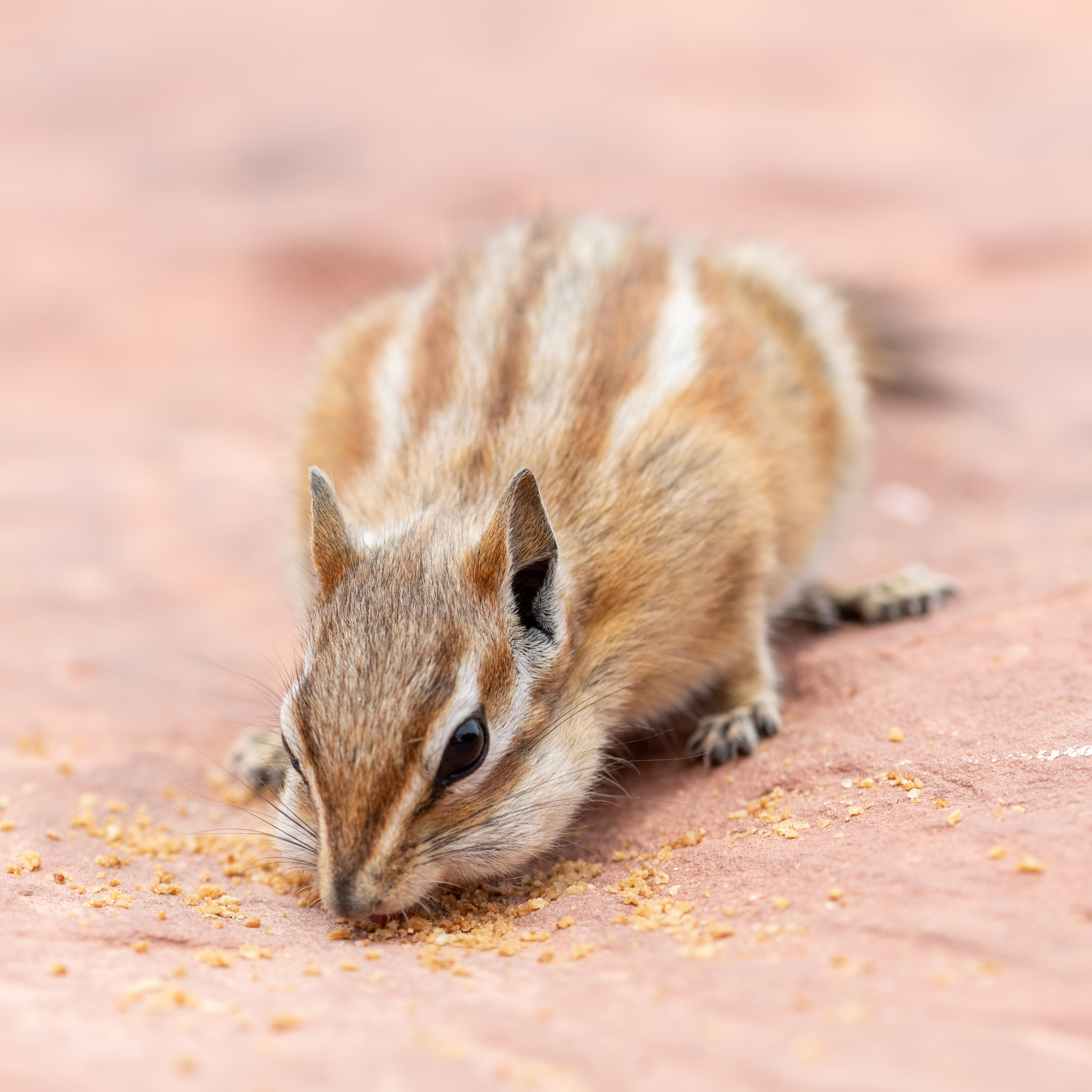
Chipmunks are everywhere !


The Fruita (orchard) area at the entrance to Capitol Reef NP


The scenic drive through Capitol Reef NP


Everywhere you look are these immense cliffs of multi-colored layered rock


The original route along the canyon through the mountains ... a rough ride I would imagine